Tag Archives: Trip Ideas

Dry Tortugas Florida Keys

Beachfront National Parks in the Florida Keys


Open spaces, fresh air and natural beauty draw us to national parks. Add a beach and you’ve got a dream getaway perfect for these times or any time. While the Keys reopened to visitors on June 1, 2020, there are protocols for safety including maintaining social distance and masking up. These three parks are primed for swimming, snorkeling, exploring or, just enjoying the laid back lifestyle of the Keys.

Dry Tortugas National Park

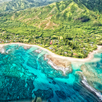
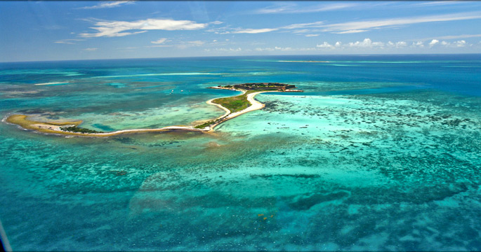
There’s no question that a trip to the Dry Tortugas should be on everyone’s bucket list. This is the nation’s most remote national park and is actually seven small islands surrounded by crystal clear waters of the Gulf of Mexico. You’ll find islands dedicated to a bird sanctuary, coral reefs rich with sea life, sandy shoals and islets to explore. Include time to meander through Fort Jefferson, an impressive circa 1800 citadel that occupies most of the 16 acres on Garden Key. One of the largest forts to be built to protect shipping lanes took almost 30 years, although, it was never completed.

Dry Tortugas

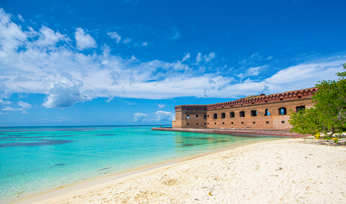
The 100-square mile park at Dry Tortugas hosts plenty of space for beach time, swimming and snorkeling after exploring the 19th-century fort. Photo: Thomas/Flickr

Due to the location and easterly flowing current the marine life is vibrant and abundant so divers and snorkelers are more than pleased. The swim area is bordered by large coral heads giving reef dwellers like parrotfish, angelfish and triggerfish plenty to crunch on. The pier pilings attract a variety of small colorful fish while the deep channel is home to grouper, tarpon and barracuda. On a swim around the moat wall expect to see reef squid, hogfish and nurse sharks. A highlight includes the trip there, either via the 70-mile ferry from Key West, a private boat or seaplane. There is no cell phone coverage so chalk this time up to digital detoxing.

Bahia Honda State Park

Touted, as the best beach in the Florida Keys, the natural sandy shores of Bahia Honda are actually three beaches. Calusa Beach is the smallest and most picturesque accented with a few palms. Portions of the long stretch of Sandspur face the Atlantic and Loggerhead with its shallow sandbar becomes the preferred spot to soak up the atmosphere from a lounge chair plunked down at waters edge.

Bahia Honda State Park

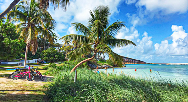
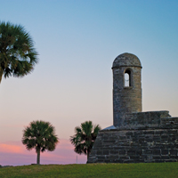
Bahia Honda’s Calusa Beach is adjacent to the abandoned Bahia Honda Bridge, once used as a railroad into the Keys. It’s most picturesque at sunset. Photo: Jane Fiala/Flickr

While many are eager to don mask and snorkel to explore the crystal clear waters, the underwater sightings are slim with a glimpse of a rare lobster blanketed in the grassy flats or a school of shy immature fish peeking out from coral cervices. To really see what the Keys has to offer in the colorful underwater world take the 12-mile boat trip to Looe Key Reef. This U-shaped marine sanctuary varies in depths from 5 to 15 feet and snorkelers of all levels will be delighted with the sightings of sergeant major, anglefish, parrotfish, grouper, stingrays and moral eels. Spotting a nurse shark lurking in the sandy bottom is not unlikely.

Fort Zachary Taylor State Park

For a bit of history beachside, this park delivers a look at Florida’s past before the Civil War. Built to hold pirates at bay in the neighboring waters surrounding the state, construction of this stronghold began in 1844 and ended in 1860. Then during the Civil War, the fort became the center for naval operations capturing Confederate ships. Today, history buffs can explore the red brick corridors lined with cannon and gun ports on their own or take a narrated tour.

Fort Zachary

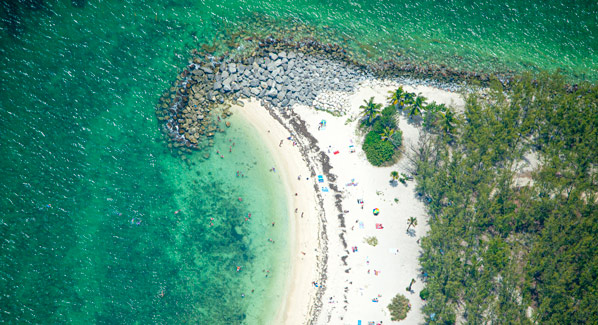
Fort Zachary Taylor is the southernmost state park in the continental United States. At the tip of Key West, it’s the best beach in town. Photo: Rob O’Neal/Florida Keys News Bureau

Beach lovers find the waters here to be Caribbean blue. The spot is where the Atlantic Ocean converges with the Gulf of Mexico keeping the waters flowing clean. While the shoreline invites with a sandy beach, a few steps in the water reveal a rocky bottom. Offshore, the rocks make an attractive environment for tropical fish, so grab the snorkel and mask for a fruitful exploration.

Kauai Aerial

Hawaii by Helicopter


Few other places in the world can match the scenic beauty and diversity of the Hawaiian Islands. From towering sea cliffs and thundering surf to waterfalls, rainforests and active volcanoes, it’s all here. And one of the best ways to experience this enticing visual smorgasbord is by air. Helicopter tours of the islands rank high on most visitors’ bucket lists, and can be booked at each of the four major islands. Here’s what to expect.

Hawaii by helicopter

Tour companies such as Blue Hawaii carry passengers in fast, turbine- powered helicopters that can reach all corners of the islands in comfort and safety. Photo: Marek Sluzarczyk/iStock

Oahu

An aerial view of Oahu takes in famous landmarks and also reveals a very different side of the island. Tours may begin with an overflight of Pearl Harbor for a bird’s eye view of the Arizona Memorial, the battleship Missouri and the historic Aloha Tower. Next comes bustling downtown Honolulu and overflights of the iconic beaches of Waikiki, Diamond Head and the glittering shallows of Hanauma Bay. Then, as the pilot heads farther east, a very different side of Oahu is revealed. The island’s interior is a realm of towering mountains, lush rainforests and hidden valleys. A soaring flight over the Pali cliffs leads to a windward coastline lined with spectacular beaches and colorful coral reefs, all set against sea cliffs where waterfalls spill from the heights. In winter months, passengers have a grandstand seat for the North Shore’s surf scene, where the best wave riders in the world gather to challenge monster swells.

Oahu Aerial

A birds-eye view of Oahu’s eastern shore, where the Kamehameha Highway runs beachside. Nearby Ahupuaa O Kahana State Park offers camping and hiking trails. Photo: Slobo Mitic/ iStock

Kauai

More than half of the Garden Isle can’t be reached by road, and there’s a lot to see on this greenest of the Hawaiian Islands. Kauai’s deep canyons, towering sea cliffs and majestic waterfalls deliver cinematic grandeur, and have been a favorite of filmmakers from South Pacific to King Kong and Jurassic Park. A typical tour route will swoop through the expansive Hanapepe Valley en route to the cascading waters of Manawaiapuna, aka Jurassic Falls. Anywhere else, the razor-thin ridges and deep clefts of Olokele Canyon would be the main attraction, but on Kauai, this remote valley is just a warm up for the even grander vistas of Waimea Canyon, the so-called “Grand Canyon of the Pacific.” Next up are the sculpted sea cliffs of the NaPali Coast, and the pristine blue waters of Hanalei Bay. For a spectacular finish, pilots head for Mount Waialeale, the wettest spot on Earth, where 3,000-foot waterfalls spill down the towering mile-high walls of an ancient crater.

Kauai Napali Coast Aerial

There are no roads on the rugged sea cliffs of Kauai’s Napali Coast. Hikers follow demanding cliffside trails to hidden valleys, but helicopter flights provide much easier access. Photo: Andrea Izzotti/iStock

Maui

An aerial tour of Maui begins with a decision: east, west or both. A flight over the West Maui Mountains takes in views of one of the wettest places on earth, with plenty of waterfalls and greenery. Also on the route are the isolated beaches of the north shore, expansive sugarcane and pineapple fields, the historic town of Lahaina and the scenic shores and resorts of Kaanapali and Kapalua. Some tours take to the sea to reach the world’s highest sea cliffs on neighboring Molokai Island. In winter and spring, there is a chance of seeing breaching humpback whales during the crossing. A circumnavigation of east Maui begins with a climb to the lunar-like landscape Haleakala Crater, Hawaii’s largest dormant volcano. Descending eastward, flights then follow a lush coastline where waterfalls sparkle amidst rainforest greens. After passing the village of Hana, the scenery changes once more to the open plains of the island’s seldom-visited southern shore. For the ultimate Maui tour, some operators offer an all- island route that showcases the full spectrum of the Valley Isle’s scenic treasures.

Maui Aerial

Maui’s surf-washed northwestern coast is flanked by tall sea cliffs. The only land access to this sparsely populated region is via a narrow, one-lane road that often hugs the cliffs. Photo: iStock

Hawaii

The Big Island is a land of contrasts and extremes. In winter, the soaring peaks of Mauna Kea and Mauna Loa are often covered in snow. A few miles to the south, the smoke and fire of Kilauea are proof that this is a young volcanic island, still rising from the sea. Overflights of this active volcano are a staple of helicopter tours originating on the east coast town of Hilo, providing passengers with a rare opportunity to witness active lava flows and massive steam clouds created when the molten rock meets the sea. These same routes also take in black sand beaches and the island’s oldest landscapes: the deep valleys and rain forests of the Kohala mountains. Longer flights originating on the island’s western shore provide a dramatic look at up to eight distinct climate-zones, included the arid coastal plains of Kohala, the ranches of the Waimea highlands and the verdant coastal landscapes of the Waipio valley and the Hamakua Coast.

Big Island Hawaii Aerial

On the south coast of the big island of Hawaii, helicopter flights provide a rare chance to witness the steam clouds created when lava flowing from Kilauea Volcano meet the sea. Photo: iStock

Florida-StAugustine-Castillo-romance-sunset

Walk this Way: Historic St. Augustine


Bring comfortable walking shoes when you visit St. Augustine, the historic town tucked in Northeast Florida on the edge of Matanzas Bay. Red brick-lined streets, the pedestrian-friendly St. George Street and squares shaded by sprawling oak trees make it easy to navigate on foot. You can trace the old city’s history of years under Spanish, British and American rule dating back to the 16th century.

Start at the Castillo de San Marcos, a fort built by the Spanish to defend the colony from the British. Besides the protection of a moat, the fort was built using blocks of coquina, a soft rock of seashells and coral from a local quarry. No invaders could crack the walls, as cannonballs fired from approaching ships dented rather than shattered the walls. Wander the casements and keep an eye out for the re-enactors in period clothing demonstrating the use of historical weapons. Next cross the street and pass through the City Gates onto St. George Street. On your right is the Oldest Wooden Schoolhouse, a one-room building of red cedar and cypress where students gathered for classes in the 1700s. A huge chain used to anchor it against hurricane-strength winds remains intact. Further down on the left is the Colonial Quarter, a garrison town depicting life under the Spanish from the 16th to 18th centuries and under the British when they took over in 1763. Venture into a soldier’s home, watch a blacksmith fire up wrought iron and climb the watchtower.

Walking St. George Street you’ll pass cafes, boutiques, candy shops and the statue of Queen Isabelle on her ass in the garden at Hypolita Street, which always gets a chuckle from passers-by. At the end sits the Plaza de la Constitución, which by government decree had to be a rectangle with a government building, church and public market. Except for the church, which was replaced with the Cathedral Basilica of St. Augustine in 1887, the other buildings constructed by the Spanish still stand.